- Views: 2K
- Replies: 1
In a landmark development for India’s strategic autonomy, the Pralay tactical quasi-ballistic missile system is set to be equipped with INDIGIS—a fully indigenous Geographic Information System (GIS).
Developed originally by the Centre for Artificial Intelligence and Robotics (CAIR), a laboratory under the Defence Research and Development Organisation (DRDO), this integration marks a decisive step toward complete indigenisation of one of India’s most potent conventional strike assets.
Securing the Digital Command Post
The integration of INDIGIS provides Pralay battery commanders with a robust, secure, and offline-capable digital mapping environment.This system allows for the precise visualisation of critical battlefield data, including launcher positions, various missile configurations (such as conventional or penetration-aid variants), real-time range rings, and target folders.
Crucially, this entire planning process will now occur on Indian-made software, eliminating the risks associated with foreign dependencies, such as data backdoors or denial of service during crises.
Historically, Indian weapon locating and fire-planning systems have relied on licensed foreign GIS engines. However, given that Pralay is a strategic asset designed to target high-value infrastructure across the borders in the initial stages of a conflict, both the Indian Army and DRDO prioritised the adoption of a 100 per cent 'Swadeshi' (indigenous) GIS core.
The INDIGIS Platform
Following a rigorous internal evaluation by DRDO, the technology for the INDIGIS platform was transferred to Bengaluru-based Microgenesis Techsoft Pvt Ltd under a commercial Transfer of Technology (ToT) agreement.Microgenesis has since customised the INDIGIS Software Development Kit (SDK) to meet the specific operational requirements of the Pralay system.
The result is a full-featured desktop GIS environment that enables units to standardise their maps using reusable templates and spatial bookmarks.
Operators can generate unlimited layers with saved symbology—specifically compliant with military standards like MIL-2525D—ensuring that every Pralay battery displays launchers, impact ellipses, and restricted zones in a uniform manner.
The system supports advanced terrain analysis, including 3D visualisation and line-of-sight calculations, which are vital for mission planning.
Operational Capabilities and "Shoot-and-Scoot"
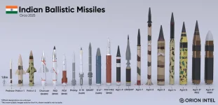
The Pralay missile, capable of striking targets at ranges between 150 and 500 kilometres, operates on a depressed quasi-ballistic trajectory with the ability to manoeuvre mid-flight to evade interception.It is launched from highly mobile 4×4 and 8×8 transporter-erector-launchers (TELs) that must constantly relocate to survive enemy counter-battery fire—a tactic known as "shoot-and-scoot."
To support these dynamic operations, commanders require a system that can provide:
- Instant visualisation of every TEL’s precise geo-position.
- Dynamic range fans tailored for different warhead types.
- Terrain masking analysis to conceal launchers from enemy reconnaissance satellites and drones.
- Rapid route planning for immediate relocation after firing.
- Overlay capabilities to map enemy air-defence radar coverage and artillery counter-fire zones.
A Strategic Trifecta
With INDIGIS now serving as the mission-planning backbone for Pralay, India has achieved a rare strategic trifecta: an entirely domestic quasi-ballistic missile, an entirely domestic guidance and seeker suite, and now, an entirely domestic GIS decision-support layer.When the first Pralay regiments become operational with the Army’s Rocket & Missile Forces—expected between 2026 and 2027—their commanders will be planning strikes using Indian maps, running on Indian code, situated on Indian soil.
This level of technological sovereignty is a capability that only a handful of nations globally can claim.