While public focus on India's border strategy along the Line of Actual Control (LAC) usually centres on troops, fighter jets, and air defence networks, a quieter and equally powerful transformation is taking place.
From Ladakh all the way to Arunachal Pradesh, India is actively building a massive, interconnected net of advanced sensors. This ambitious project aims to keep a constant watch on Chinese military movements across the highly complex Himalayan terrain.
The building blocks of this network—including Mountain Radars, Arudhra and Ashwini advanced radars, military satellites, low-level surveillance systems, and the Integrated Air Command and Control System (IACCS)—are no secret.
However, the real game-changer is how these separate tools are being fused into one unified surveillance web.
This massive upgrade gained urgency after the 2020 Galwan Valley clash.
Since then, China’s Western Theater Command has heavily fortified its presence in Tibet and Xinjiang, constructing new airbases, drone hubs, and hardened military shelters.
To counter this, India is shifting its strategy from relying solely on patrol vehicles and aircraft to establishing total sensor dominance over the region.
The ultimate goal is clear-cut: to identify incoming Chinese threats—whether they are stealth fighters, drones, helicopters, or cruise missiles—at the earliest possible moment, completely unaffected by bad weather or deep mountain valleys.
Overcoming Himalayan Blind Spots
Setting up such a system in the Himalayas, however, is a monumental task. The towering ridges and deep valleys create natural blind spots, often referred to as radar shadows.These geographical barriers allow low-flying aircraft to hide behind mountains, making them virtually invisible to traditional tracking systems until they are dangerously close.
To solve this problem, India is deploying a multi-layered strategy where the strengths of one sensor cover the weaknesses of another, ensuring no threat goes unnoticed.
The Shield in Space
Space forms the highest layer of this shield. Although they rarely make headlines compared to fighter jets, military and dual-use satellites are the bedrock of India's border monitoring, beaming down a continuous flow of data from above the Himalayas.Powerful satellites like CARTOSAT track the construction of enemy airfields and troop movements, while RISAT satellites use radar imaging to see clearly through thick clouds and storms.
Meanwhile, the EOS series maintains a steady gaze on the ground, and EMISAT specializes in intercepting electronic signals and communications.
Upcoming space missions will further boost India's ability to intercept electronic and signal intelligence. These advanced space assets will be able to spot suspicious activities—like the movement of missile launchers or aircraft fueling—before an enemy plane even takes off.
Crucially, this satellite data is expected to be piped directly into active combat networks like the IACCS, rather than just being filed away in intelligence reports. This direct link means military commanders will have access to near-real-time tracking across the border.
Eyes in the Sky
Below the satellites is the airborne layer. China holds a geographical advantage with its high-altitude airbases in Tibet.India is leveling the playing field by deploying Airborne Early Warning and Control (AEW&C) aircraft, essentially acting as "eyes in the sky" to spot threats from afar.
The Indian Air Force currently relies on the homegrown Netra Mk1 fleet—which notably achieved its Final Operational Clearance (FOC) recently in June 2026—and the heavy-duty Phalcon AWACS. Moving forward, the focus is shifting to the highly anticipated Netra Mk2 project.
Approved by the Cabinet Committee on Security in July 2025 with a budget of ₹19,000 crore, the Netra Mk2 will be built on modified Airbus A321 jets.
These planes will feature a powerful dorsal radar offering 300-degree coverage, alongside a specialized nose antenna. Their primary mission will be to track stealth targets and look down into Himalayan valleys, catching targets that ground-based systems might miss.
The Ground Game: Mountain Radars and Mobile Systems
On the ground, the Mountain Radar network serves as the robust foundation of this entire defensive structure.The recent placement of these specialized radars in Gulmarg and Nagaland highlights a smart geographic strategy.
The Gulmarg setup watches over critical flight paths heading into Ladakh and northern Kashmir, while the Nagaland radar secures the eastern skies leading into Arunachal Pradesh.
These two sites represent just the beginning of a much larger effort to fortify both the eastern and western flanks of the LAC.
Over time, similar systems are expected to pop up in Himachal Pradesh, Uttarakhand, Sikkim, and deeper into Arunachal Pradesh, forging an unbreakable radar chain along the border.
Working alongside the Mountain Radars is the Arudhra Medium Power Radar system. While often seen as a basic air-surveillance tool, Arudhra is actually a crucial node that links directly with the IACCS.
It can monitor multiple fast-moving targets like fighter jets and cruise missiles simultaneously, ensuring there are overlapping fields of vision across the frontier.
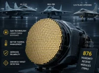
Adding tactical flexibility to the mix is the Ashwini AESA radar. Because it is highly mobile, military forces can quickly transport and deploy Ashwini units to active hotspots during border standoffs, instantly boosting surveillance in vulnerable areas.
For targets skimming close to the ground, India is heavily investing in low-level detection systems like the Bharani and the Low-Level Lightweight Radar Mk-II.
Combined with new anti-drone technology, these sensors specifically hunt for helicopters, drones, and cruise missiles that try to sneak through mountain passes.
Securing low altitudes is critical today. Defence planners understand that future border skirmishes will likely involve swarms of drones and low-flying precision weapons rather than traditional high-altitude dogfights.
Silent Sentinels and the Central Nervous System
Alongside active radar towers, India is also relying on silent, passive surveillance networks.These stations quietly listen for enemy communications and electronic signatures without emitting any signals themselves. Because they remain "quiet," they are incredibly difficult for the enemy to locate and destroy, yet they provide a wealth of intelligence.
This passive listening is especially useful for countering stealth technology. China’s air force is rapidly expanding its fleet of stealth fighters, like the J-20 and the upcoming J-35, along with advanced unmanned combat drones.
The trick to defeating stealth is not necessarily achieving a perfect lock-on, but simply detecting its presence early.
By investing in multi-band and VHF radars, along with passive detection, Indian forces can pick up faint traces of a stealth jet and guide more precise targeting sensors to zero in on it.
The glue holding this massive framework together is the Integrated Air Command and Control System (IACCS)—arguably the most critical piece of India's defence puzzle.
Without it, every satellite, ground radar, and airborne sensor would operate in isolation. The IACCS seamlessly fuses the raw data from space, the sky, and the ground, presenting commanders with a single, live, and unified map of the entire battlefield.
Functioning as the central nervous system of India's airspace, this automated network allows military leaders to assess threats and dispatch interceptors across thousands of miles almost instantaneously.
The Future of Frontier Surveillance
The sheer amount of data pouring in from these varied sensors will soon be too much for human operators to handle alone, paving the way for Artificial Intelligence.In the near future, AI algorithms will likely take on the heavy lifting—automatically identifying hostile flight paths, flagging unusual enemy deployments, and even suggesting the best countermeasures before a human operator even looks at the screen.
The overarching strategy is undeniable. China has placed immense reliance on a string of fortified airbases across Tibet—such as Hotan and Lhasa Gonggar—arming them with advanced drones and stealth aircraft.
In direct response, India is weaving a flawless net of persistent surveillance. Instead of relying on a few scattered radar dishes, India has built a sophisticated, deeply integrated ecosystem that guards the nation from space, the skies, the ground, and across the electromagnetic spectrum.